
Look here for postings of major changes to the Rights of Way network in our Area.
Enfield Permissive Paths and rural Rights of Way
**** DIVERSIONS FROM M25 BRIDGE AROUND HOLLY HILL FARM **** (see 12 March 26 update below)
Enfield has a great network of rural permissive paths - in theory. Unfortunately, both the permissive paths and the rural Rights of Way are not maintained frequently enough. Bramble has been allowed to grow unchecked and has now rooted in the surface of the paths so that it quickly blocks them after clearance. In addition, there are unsafe structures. Three years ago, broken stiles were all replaced with new stiles (NOT gates): perfectly sound, but hard work if you take a route which uses them all (up to 11 stiles in a couple of miles!) Broken bridges are the current problem.
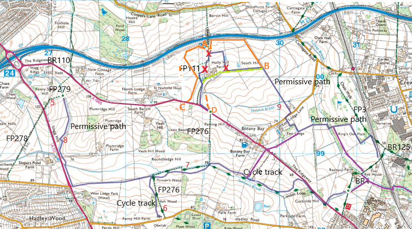
The map below shows the footpath network south of the M25 and west of Crews Hill. There are few Rights of Way. FP 111 goes around Holly Hill Farm, but what is on the ground bears no relation to what is shown on OS maps. FP 276 is otherwise known as the Jubilee path – created in 1978 to celebrate the Queen’s Silver Jubilee. BR 110 with FPs 279 and 278 head across to Waggon Road in Hadley Wood. Further footpaths were constructed as permissive paths over the following decades, with most of the work done by volunteers. These are labelled “permissive paths” on the map below.
In recent years, Enfield have been carrying out a huge flood prevention and reforestation project. This has included the construction of new cycleways along the Salmons Brook and Turkey Brook valleys, which now go under the railway viaduct to link with Hilly Fields. It is a wide meandering track with a self-binding soft surface, running alongside the existing FP 276 and London Loop route. Whilst this project is opening up new routes, the longer established routes are being neglected.
This page will be used to give you the latest information we know on the status of the paths. If you have anything to report, problems or repairs, please email
12 March 26 Holly Hill Farm Enfield have now provided an official diversion to FP111 around the flood prevention work taking place north of Holly Hill Farm. This is shown in orange on the map by the line A to C. Coming south from the M25 bridge, turn immediately right/west. It heads up a wide muddy track used by construction vehicles, climbing up to the far side of the bund. You need to be a strong walker to tackle it, preferably using poles, as the mud is so deep. It then crosses open space to emerge onto the Ridgeway west of the Holly Hill Farm track.
There is also a diversion for those wanting to follow the permissive paths, shown as A to B. It is a bumpy grassy surface going right beside the M25 for a stretch. It is well signed coming south over the M25 and not too far out of your way. If you are going north along the permissive paths, be sure to go straight ahead when you reach point B at the top of the hill, do NOT turn left towards Holly Hill Farm as you used to. This is now clearly signed.
If you are trying to use the official diversion of right of way FP111 going north, you will need to walk west along the Ridgeway to find point C. At the bottom of the farm track from the Ridgeway, there is no signage to warn you of the path closure.
You could follow the old route up the farm track but continue straight on past Holly Hill Farm, bearing right on the wide track (mapped in light green) past the model aircraft club until you reach point B. Or more scenic, you could cross the field opposite the top of FP276, from point D, to join a track going up to the farm. The link through the farm is NOT a legal right of way, so you may be challenged or find your way blocked. I have been told that work is now taking place in the area SOUTH of the track mapped in light green, so attempts to go through may be dangerous.
As far as I know, there are no changes to problems at 5 (blocked with bramble, use the field beside), 6 & 7 (ROW gone, use cycleways), 8 (no bridge so closed) and 9 (dodgy bridge).
Nov 25 More new cycleways were officially opened in October. You can see the latest ones in purple on the map. You can now walk (or cycle) from the London Loop south of the Ridgeway directly north to Botany Bay (where there is a picnic area with a lovely view). Continuing over the Ridgeway, the cycleway heads north east down to Turkey Brook, then south east alongside Turkey Brook to Rectory farm, then under the Rendlesham Viaduct to Hilly Fields, just off the edge of the map.
Sept 24 Paths marked 1 to 7 were completely closed off with bramble, impassable. Paths 6 and 7 (parts of FP 276) have the new cycleway beside them. However, path 6 is a useful straight alternative to the meandering cycleway where it goes down the hill. Path 7 is not worth retrieving, as it was always difficult to maintain and got extremely muddy. The stile at 10 was broken.
April 24 At point 8, the bridge across the steep sided ditch has completely broken, making the path unusable. At point 9, the bridge has a broken handrail and the stream is blocked underneath so that it floods in wet weather.
Tyttenhanger Estate / Willows Farm
The new improved network of footpaths has been open for business for some time. They are now shown in full on the Herts CC RoW map, and will be on the next official printed Definitive Map. However, they are not yet shown in full on the latest OS Maps, not even the on line version. Therefore, for a map of the current network, use this summary OS map (printable copy of the one shown on this page) showing the new and altered routes.
The new Knebworth path
The new footpath confirmed in Knebworth Park is now shown on the Herts CC RoW map, but not yet on OS maps. This PDF includes a map of it.
Hertfordshire Definitive Map changes
Hertfordshire CC Countryside & Rights of Way aim to produce the latest consolidation of their legal Definitive Map and Statements this year (they normally consolidate the DM&S every 5 years). In the meantime, most changes that have already been fully implemented will be visible on the on-line version of the map, as it is updated frequently.
For details of past and possible future changes, you can see the documents relating to Definitive Map orders on the Hertfordshire website. This link takes you to an A to Z by parish of all documents relating to Rights of Way applications, both confirmed and still being processed.